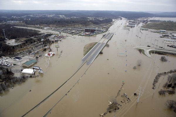
Flooding shuts down major interstate near St. Louis
Nine levees – five on the Mississippi River, three on the Missouri and one on Illinois’ Kaskaskia River – were topped by water, but those earthen barriers protect farmland and otherwise unpopulated areas. The Mississippi at St. Louis was forecast to crest Thursday at 42.5 feet, 12.5 feet over flood stage at the Arch and just shy of the 1973 flood, which would remain the city’s second-worst.
The National Weather Service said flooding can be expected in Missouri, Illinois, and Kentucky, with record flooding at several locations.
Historic floods on the MS in 1993, 1995 and 2011 occurred during warm weather, after snow melts in the north. AccuWeather senior meteorologist Alex Sosnowski called it highly unusual to have heavy flooding in winter and said it could presage trouble for the spring.
Flooding from the Meramec forced closure of a 3-mile stretch of Interstate 55 south of St. Louis, snarling traffic for the few commuters working on the eve of the new year.
“The other alternates that we would have sent motorists to basically have water on them as well”, Elliott said. “We were out there all night sandbagging trying to hold it back as much as we could, but it was just so much”.
Officials as far south as Louisiana are preparing for flooding as the deluge makes its way slowly down to the Gulf of Mexico.
“It’s cold out there”, Nixon said.
Other forms of transportation were equally problematic.
A 24-mile stretch of Interstate 44 was closed at Valley Park southwest of St. Louis due to Meramec River flooding.
Franklin County officials estimated that the flood damaged about 380 homes and 70 businesses, majority along the Meramec in and near Pacific, but also in Union, where the Bourbeuse River reached a record crest Tuesday before falling quickly.
Kimberly Clark, Alton City Council coordinator, said Public Works Department personnel will be manning the pumps pulling out thousands of gallons of water per minute from storm sewers through the weekend at State Street and West Broadway, until the water recedes. About 20,000 people are without drinking water in the area.
Almost a dozen other levees were considered at risk for “possible significant distress”, but they were holding as of Wednesday evening. Hundreds of volunteers formed human chains to spread sandbags on levees before the rapidly rising water could overflow them.
Two wastewater plants were shut down – at Fenton and Valley Park – allowing raw sewage into the Meramec.
In some of the worst flooding in history, parts of the greater St. Louis area is underwater.
In the southwestern Missouri tourist mecca of Branson, residents of about 150 duplexes and homes had to evacuate on Wednesday because a manmade lake flooded. Gov. Bruce Rauner is scheduled to return early from a vacation outside the U.S.to visit flood-damaged areas.
In Illinois, disaster declarations have been made in affected counties.
In this aerial photo, homes are surrounded by floodwater, December 30, 2015, in Pacific, Mo. A rare winter flood threatened almost two dozen federal levees in Missouri and IL on Wednesday as rivers rose, prompting…
Points in southern Missouri and IL are still awaiting the crest.
The Mississippi Valley Division of the U.S. Army Corps of Engineers announced Tuesday that it fully activated its flood-fighting emergency management operations for the Rock Island, St. Louis, Memphis, Vicksburg and New Orleans districts to manage rapidly rising water levels on the rivers.


